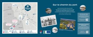
The port is a place of work, but also of leisure.
You’ll discover that Audenge once had a very popular beach, that the town has three harbours, and how a flushing basin became a pleasant swimming area.
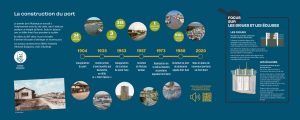
The construction of the port
Audenge’s first port was located where the city-stadium is today, but it was impractical because it was far from the Arcachon Basin. Only boats with a shallow draught could access it.
By the mid-19th century, the port was silting up. It became necessary to build a new port.
Work began in 1894 instigated by Armand Duvigneau, mayor of Audenge.
- 1904: Inauguration of the port
- 1935: Construction of a café which became the « Petit Casino » in 1938
- 1953: Inauguration of the statue of Saint Yves
- 1957: Construction of the Verdier lock
- 1973: Construction of the secondary dock (basin) known as Port Nord
- 1988: Development of the Port Sud marina
- 2020: New pontoons at the Port Nord
The port in numbers
- 34 oyster shacks
- 3 ports
- 315 boats
- 1 swimming facility
- 938 meters from the statue of saint Yves to the playground
The dykes and locks
A dyke is a long structure designed to keep water out.
In Audenge, the first dykes were built by the Marquis de Civrac, Baron of Audenge and Captal Lord of Certes, who wanted to develop saltworks on his estate. Between 1768 and 1773, 30 kilometres of dykes were built. With a maximum height of 5 m above sea level, they were made of clay.
In addition to the salt marshes, several other dykes have been built along the harbour. At the end of one of these is the monument dedicated to saint Yves.
Locks are used to control water levels.
To do this, a gate opens and closes to let the water in or out. In salt marshes, the sluice is said to make the marsh « drink » when it fills up with salt water and « empty » when it empties. The sluice gate is activated by a special key that allows it to slide up and down on a rail using a large worm screw.
There are several locks in the harbour, including one for emptying or filling the bathing facility. The old lock where we are standing was filled in when the marina, also known as Port Sud, was developed.

Audenge personalities linked to the port
The Marquis de Civrac (1727-1773)
François Eymery de Durfort, Marquis de Civrac, was Baron of Audenge and Captal Lord of Certes. He owned an estate of over 120.000 hectares in which he developed salt marshes. To make them work, he called on salt workers from Saintonge and created a new district to house them, Les Places.
Ernest Valeton de Boissière (1811-1894)
Ernest Valeton de Boissière, a graduate of the Ecole Polytechnique, inherited the Certes estate (Domaine de Certes) in 1843. He transformed the salt marsh basins into fish tanks and developed fish farming. He made significant progress in this field, for which he was awarded the silver medal of the Bordeaux Academy of Science and Letters in 1856.
Armand Duvigneau (1844-1928)
Armand Duvigneau was mayor of Audenge from 1885 to 1922. With his brother Jacques (mayor of the town from 1870 to 1885), he built the « new Audenge ». This included the development of the harbour, with its flushing basin that was to become the bathing facility. He also created the public garden and the avenue of plane trees on Boulevard Gambetta, and brought electricity to the town.
Claude Verdier (1918-2009)
Claude Verdier was mayor of Audenge from 1983 to 1995. He is the son of Jean Verdier, a doctor who was mayor of the town from 1947 to 1951. Claude Verdier created the second, south marina and developed the bathing facility beach. The old lock where we are now bears his name. He was also behind the twinning with the town of Azagra in Navarra (Spain) in 1994.
The oyster port
Designed for professionals of the sea, whether oyster farmers or fishermen, the harbour has 48 berths. The shacks that line the harbour are used by oyster farmers to store their equipment. Some have been converted into spaces where you can try the oysters. One of them, the Cabane à Jeannot, is a traditional oyster hut that you can visit. The last one, the Cabane Bleue, is a space for art exhibitions.
The Escalopier Estate (le Domaine de l’Escalopier)
This 116-hectare estate was created between 1770 and 1773 by Count Pierre de Pardaillan. It was nicknamed the « Renfermé d’Audenge » because of the numerous dykes surrounding it. It was Marie Joseph Charles de l’Escalopier, honorary curator of the Arsenal library in Paris, who gave it his name when he married the estate’s heiress in 1836. The l’Escalopier estate is still privately owned.
Marinas
Two marinas surround the oyster harbour. The one to the north is the oldest.
It is equipped with a heritage pontoon reserved for traditional boats from the Arcachon Basin. These two harbours can accommodate 267 sailing and motor boats. They require constant maintenance and must be regularly de-silted. The silt collected is reused.
The Graveyron estate (le Domaine de Graveyron)
This 135-hectare estate is organised around two main areas: a dyked marsh and salt meadows with a farm. The Graveyron ponds have never produced salt, but have been successfully used for fish farming. In 1998, the Conservatoire du Littoral bought the estate after the death of its last owner, Anne-Marie de Moneys d’Ordières. A footpath leads around the estate.
The monument to saint Yves
Saint Yves, a 13th-century Breton priest, is the patron saint of sailors and lawyers. In Audenge, he is also a healing saint. There is a statue of the saint in the church, which has been the subject of pilgrimages and remains important to some Christians today. The monument to saint Yves was inaugurated on 19 May 1953, the saint’s feast day. Every year on this day, there is an open-air mass, a tribute to sailors lost at sea and a blessing of the boats.
The monument depicts saint Yves in religious garb. The anchor above his head symbolises sailors. The pouch at his side, into which he plunges his hand, illustrates his many donations to the poor.
A short history : the great misfortune
In 1836, on 28 March, 78 sailors drowned in a severe storm. The event is remembered as « The Great Misfortune ».
On 23 March, eight longboats set sail from the nearby port of La Teste for a six-day fishing trip. On board each boat were 13 fishermen. On 24 March, only two of the boats arrived back in port. The others fought with the waves, which prevented them from entering the Basin. They turned back before trying their luck again on 27 March.
In the morning, coming from the open sea, the six longboats set off again to attack the passes. The sea was as rough as ever, and the manoeuvres proved difficult. All day long, under the watchful eyes of the locals and the customs officers on duty on the coast, they tried to get around the breakers. At night, a strong wind picked up. The morning of the 28th revealed a nightmare scene. The wreckage of boats and pieces of nets were everywhere. None of the 78 sailors out fishing survived. The tragedy plunged the whole Basin into mourning. While most of the sailors were from La Teste and Gujan-Mestras, Audenge lost 12 men.
Children’s corner: talking about the tide
What is a tide?
You’ve probably noticed that the Arcachon Basin empties and fills up twice a day.
This phenomenon is known as the tide. The tide is said to be « high » when the edge of the sea comes up to the coast and « low » when the sea goes out.
There are 2 high tides and 2 low tides a day.
What about the tidal coefficient?
The tidal coefficient is an indicator of the size of the tides. It ranges from 20 to 120. A high tide is defined as 90 or more. During the very high equinox tides in spring and autumn, the port of Audenge is under water!
Where does the tide come from?
To understand the tides, you have to look up at the sky! Tides are caused by the interaction between the Sun, the Moon and the Earth.
The tide is high when the Moon or the Sun draws the water in the Basin towards them, raising its level. Conversely, when the surface of the water is no longer attracted by the moon or the sun, the tide is low.
Where does the water go at low tide?
The water doesn’t go anywhere, it just rises and falls!
Estran, schorre, vasière, what do they mean?
The estran (foreshore) is an area covered and uncovered by water during tides.
The schorre (salt meadow) is an area of the estran which is covered by seawater at times of high tide coefficients.
The vasière is a zone covered by silt.
These three zones are home to typical flora and fauna :
- Sea aster
- Sea purslane
- Perennial glasswort
- Seaside arrowgrass
- Dwarf eelgrass
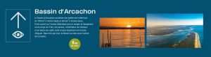
Arcachon Basin
The Arcachon Basin is a small inland sea covering 174 km² at high tide and 60 km² at low tide. It is open to the Atlantic Ocean via the passes, a single, dangerous entrance 3 kms wide, made up of channels and sandbanks, the most important of which is the Banc d’Arguin. Twice a day, the Basin is emptied by the tide.
8 km of shoreline

L’Escalopier estate
A 116-hectare dyked estate, created between 1770 and 1773. Its basins were intended for salt works, but were eventually turned over to fish farming, which was more profitable.
116 ha in area / Private estate
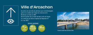
Town of Arcachon
Arcachon is a fishing town that grew thanks to the creation of the Bordeaux-La Teste railway line in 1841. It was a former district of La Teste-de-Buch and became a town by imperial decree of Napoleon III on 2 May 1857.
From Audenge : 17 kms in a straight line – 20 kms or 12.5 miles by boat – 30 kms by road
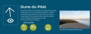
Dune du Pilat
It took 4.000 years of sand accumulation to form the Pilat Dune, as we know it today. It is over 500 m wide from west to east and just under 3 kms long from north to south, and contains around 55 million cubic metres of sand. It is the highest dune in Europe.
Height: up to 106 m – From Audenge: 30 kms by road – in a straight line: 17 kms
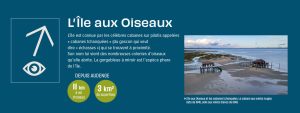
L’île aux Oiseaux (Bird Island)
The island is famous for its stilt houses, known as « cabanes tchanquées » (from the Gascon word for « stilts »), which can be found nearby. Its name comes from the many colonies of birds that live there. The bluethroat is the island’s special bird.
From Audenge: 11 kms in a straight line –3 km2 in area
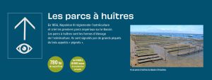
The Oyster beds
In 1856, Napoleon III regulated oyster farming and created the first imperial oyster beds on the Basin. The oyster beds are where the oysters are farmed. They are marked by large wooden posts called « pignots ».
780 ha in area – from 8.000 to 10.000 tons produced each year

Audenge Beach
This beach was once very popular with the people of Audenge. Bathers could change in peace and quiet in the bathing huts provided.

Monument to saint Yves
Saint Yves is a Breton saint, patron saint of sailors and lawyers. Every year in May, a large popular festival is organised.
19 May: Festival of Saint-Yves

Oyster shacks
The workplace of oyster farmers and fishermen. All decked out in bright colours, some have been converted to become oyster tasting areas.
The last one, in blue, is a space for art exhibitions, with a yearly programme.
47 shacks – 2009: creation of the Cabane Bleue

Oyster harbour
Built in 1894, this is the oldest of Audenge’s three harbours. The oyster harbour is primarily used by professional seafarers whose boats are no more than 12 m long, 3.50 m wide and have a maximum loaded draught of 1.50 m.
48 boats can dock there.

The Marinas
267 boats can berth here, on either side of the oyster harbour.
On the left, the north marina is the oldest and can accommodate 123 boats. Opposite, the south marina, the most recent, can accommodate 144 boats.

Graveyron Estate
A 135-hectare dyked area of salt meadows and fish ponds. The site is owned by the Conservatoire du Littoral, which acquired it in 1998 after purchasing the Certes Estate (Domaine de Certes) in 1984. The Domaine de Certes et Graveyron is a 530-hectare natural area.
135 hectares – Domaine de Certes et Graveyron
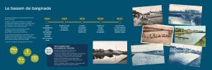
Swimming facility
Timeline :
- 1894: Beginning of the development of the port. Creation of a flushing basin to evacuate the silt
- 1929: Creation of the swimming club: « La Mouette »
- 1976: The swimming facility is named after Émile Ortel
- 2008: Creation of a beach at the swimming facility
- 1976: The swimming facility is named after Émile Ortel
- 2023: Mineral resin walkways laid down. New urban furniture is added
This swimming facility is the largest seawater pool in Europe.
In 1904, the new port in Audenge was inaugurated. It is equipped with a flushing basin that has a lock which acts like a flush, to evacuated the silt from the ouster port.
The flushing basin iwa transformed into a swimming pool at the end of the 1920s. It was named after Émile Ortel in 1976.
Some of the water in the swimming facility is changed at each tide. It is carefully monitored by the hygiene and health department of the Syndicat Intercommunal du Bassin d’Arcachon (SIBA).
The swimming facility is used all year round.
Figures :
- 170 m long
- 17 m wide
- 3 pools
- From 30 cm to 1.90 m deep
News item: one drowning can prevent others
In the summer of 1928, a Polish man from the Brun sawmill drowned. No one was able to come to his aid. In the aftermath of this tragic accident, a number of people in Audenge, including Emile Ortel, wanted children and adults to learn to swim. The « La Mouette » swimming club was founded in January 1929. Two years later, 44 children had learned to swim. By the age of 16, swimmers had to be able to cover 200 m in front crawl in 3 min 50! In 1936, « La Mouette » ceased its activities. The club was revived in 1954. Audenge people have become swimming champions.
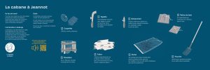
The cabane à Jeannot
A Place of work
Oyster farmers store and repair their tools in their shacks. They can also run their business there. This shack belonged to Jeannot, a former oyster farmer from Audenge.
Oyster farming in Audenge
Oyster farming was officially born in 1856, when Napoleon III created the first imperial oyster beds in Arcachon. However, the Marquis de Civrac had already set up oyster beds on his estate almost a hundred years earlier. They were located along the dykes and were cultivated by the salt farmers.
Tools
Oyster farming requires a lot of tools. Here are a few of them.
You can see them on old postcards, and some of them in the Cabane à Jeannot. And for once, you can look through the window!
- Tapette: curved metal tool used to strike or scrape the metal bars (tables) to remove oysters.
- Panetière: a net basket to collect and transport oysters.
- Tuiles: (tiles) used mainly in the Basin as nurseries. They are covered with a mixture of lime and sand. This is known as « liming the tiles ».
- Patins de bois: (wooden clogs) they stopped the people working in the beds from sinking into the silt.
- Coupelles: used as nurseries.
- Démanchoir: knife used to separate oysters from their support or to loosen shells that have been welded together.
- Poche: (oyster bag) a mesh bag in which the oyster farmer places the small oysters before putting them on metal tables out at sea to grow.
- Fourchette (fork): used to pick up the oysters and place them in the baskets.